

Click here for LIVE radars, fire and weather information
CFA - Emergency Contacts
- Victorian Bushfire Information Line: 1800 240 667
- http://emergency.vic.gov.au
The Wimmera Mail-Times has closed its rolling coverage of the Grampians fires. For the latest information, please visit the link above and follow CFA advice.
Subscribe now for unlimited access.
$0/
(min cost $0)
or signup to continue reading
11.50AM
NORTHERN Grampians Shire business services and tourism manager Debbie Bach believes Halls Gap businesses are being encouraged to open.
She said people would soon start to return to the tourism hub.
9.45AM
HALLS Gap and Dadswells Bridge are now open to the public.
The Western Highway has also re-opened.
Horsham Incident Control Centre media officer Robyn Hobbs said a relief centre was still operating in Stawell.
She said from 10am the Horsham Senior Citizens Centre would act as a community information point for people.
Community meetings: 2pm, Dadswells Bridge hall; 4pm Stawell's Grampians Community Health Centre on Patrick Street; 6pm, Halls Gap's Parks Victoria office on Grampians Road.
6AM
THE clean-up and recovery from the Grampians Northern Complex fire has started with a number of communities and roads reopening.

Incident Controller Andrew Morrow said while there were still some sections of the fire that were not under control, emergency services had focused on returning residents to their homes and opening major roads, where it is safe to do so.


“Overnight there has been some works occurring on the Western Highway to remove fallen trees and this morning we’re expecting to open this stretch of road from the intersection of Stawell-Warracknabeal Road to Horsham,'' he said.
“There is still a lot of work to do in back-burning and blacking out to ensure the fire is safe, but we also need to move in to the recovery stage so that the wider Grampians area can get back to operating as usual.”
On Saturday, the Horsham Incident Control Centre also took over control from the Ararat ICC of the Bunjils Cave Road fire at Black Range, south-west of Stawell.
Horsham ICC has also taken over from the Hamilton ICC for a number of fires in Southern Grampians that are now all contained or controlled.
“Late last night the Black Range bushfire took an unexpected turn and jumped containment lines, moving towards Stawell but the threat has now eased and we have an advice message current for this fire,'' Mr Morrow said.
"There is still a significant amount of work to do in establishing control lines and blacking out in some difficult terrain.''
Mr Morrow said all parts of the Grampians North Complex fire had been downgraded to an advice message.
Fire-fighters will continue to back-burn at the southern end of the Mt Difficult Range near Halls Gap.
“Back-burning works progressed well overnight and we’re hoping to take advantage of more favourable weather conditions over the next few days to complete these works,” Mr Morrow said.
Pomonal has reopened and Halls Gap was opened to residents.
Today it is expected Dadswells Bridge will reopen and Halls Gap will be open to the public.
The Grampians National Park will remain closed until noon on January 20.
Residents and people visiting the Grampians can keep informed with the latest traffic information and road closures by visiting www.vicroads.vic.gov.au
6PM
THE Black Range-Stawell bushfire is moving towards the outskirts of the Stawell township.
THe Country Fire Authority has issued an upgraded watch and act message for Black Range.
The bushfire has been changed by unexpected conditions that caused it to jump containment lines.
The fire is now expected to impact the outskirts of the Stawell township between Panrock Reservoir Road, Pomonal Road and properties on the southern side of the Western Highway any time in the next four hours.
CFA says: Don't wait, leaving now is the safest option - conditions may change and get worse very quickly. Emergency services might not be able to help you.
Travel to: The Relief Centre at Stawell Leisure Centre, 49-51 Houston Street, Stawell; the home of family or friends that is away from the warning area, remember to register at the Relief Centre prior to leaving the area.
THE CFA has also updated a watch and act message for Dadswells Bridge and St Helens Plains.
Fire-fighters have stopped the spread of the bushfire in the Dadswells Bridge area at the Western Highway, although it is not yet under control.
Fire activity in the Dadswells Bridge and St Helens Plains area north of the Western Highway has subsided.
Smoke might be visible in the area due to fire-fighters back-burning at the southern end of the Mt Difficult Range this afternoon and into the evening.
These burns are to consolidate the southern edge of the fire.
Continue to stay informed and monitor conditions.
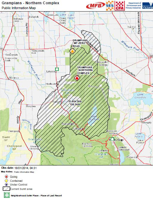
AN UPDATED watch and act message for Grampians Junction, Halls Gap, says the fire, in the northern end of the Grampians National Park, is about 51,800 hectares in size.
The fire is west of Halls Gap in the Mount Difficult Range and is not yet under control.
A a spot fire is burning in the Silverbands Falls area.
Fire activity remains in the Northern end of the Grampians National Park, but the main threat to Halls Gap and Grampians Junction has now passed.
3PM
HALLS Gap township will be open at 4pm for residents to return to their homes.
The Department of Environment and Primary Industries and Country Fire Authority have updated the road situation in and around Northern Grampians.
The Grampians Road and Western Highway to Stawell is open to traffic.
The Western Highway is still closed between the intersection of the Stawell-Warracknabeal Road and Horsham.
It is expected this section of the Western Highway will open later today, pending advice from Victoria Police.
Grampians Tourist Road and Silverband Road within the Grampians National Park, next to Lake Bellfield is closed to general traffic.
Emergency services vehicles can access this area.
Pomonal Road and Burgh Street, Stawell is open to traffic.
Ararat-Halls Gap Road and Moyston Dunkeld Road, Moyston is open to traffic.
Pomonal township is now open for residents only, to return to their homes.
Incident Controller Andrew Morrow said the CFA spent Saturday morning assessing the full impact on homes.
"A focus will also be on clearing any tree hazards, however residents need to be aware that this remains a danger after any fire," Mr Morrow said.
"Today we'll also look where we can return those who have evacuate their homes."
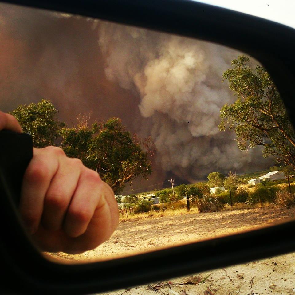
Fire Services Commissioner Craig Lapsley said on Friday that the Grampians fire was so intense it had 'created its own weather', triggering lightning and spot fires around Halls Gap.
Mr Lapsley said the Grampians fire could be seen from kilometres away and had 'a 12-kilometre convection column … that is creating its own weather'.
Stay informed
- Via www.depi.vic.gov.au
- Tune to ABC Local Radio, commercial and designated radio stations or Sky News TV
- Call the Victorian Bushfire Information Line on freecall 1800 240 667
- Deaf, hard of hearing, or have a speech-communication impairment can contact VBIL via the National Relay Service on 1800 555 677
- Download the FireReady App and follow CFA on Twitter or Facebook
- Road closures: check VicRoads website
By Saturday afternoon, all the state's major warnings were at a 'watch and act' level.
1.40PM
THE main threat to Halls Gap and Grampians Junction has now passed, as the CFA downgrades its warning for the area to Watch and Act.
The fire in the northern end of the Grampians National Park is now about 51,800 hectares in size. It is not yet under control and a spot fire is burning in the Silverbands Falls area.
The Grampians National Park remains closed until Monday.
The Western Highway remains closed between the intersection of the Stawell-Warracknabeal Road and Horsham.
Check VicRoads or call 13 11 70 for the latest information.
12.30PM
SOME incredible images and videos have been shared on social media over the past few days.
If you've taken your own photo, tag us @wimmeramailtimes on Instagram, inbox us on Facebook or email newsdesk@mailtimes.com.au. View our fire gallery here.
Please stay safe, everyone.
NOON
FIRE-FIGHTERS have stopped the spread of the bushfire in the Cherrypool area and fire activity has subsided.
The Country Fire Authority has issued an updated advice message for Cherrypool, Glenisla Crossing and Wartook.
The bushfire is not yet under control.
The CFA has encouraged people to monitor conditions and decide what they will do if the situation changes.
The Henty Highway is now open.
11.15AM
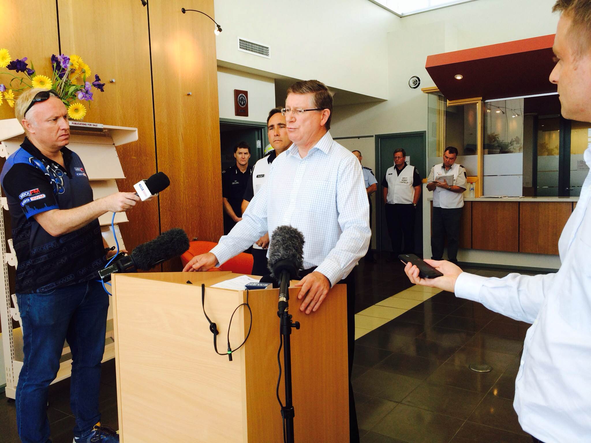
PREMIER Denis Napthine: "We understand tourism is vital for Halls Gap, Zumsteins and the Grampians and we will be working with tourism operators to boost tourism in this area and to promote Halls Gap and the Grampians."
Read what Dr Napthine had to say about the fires while in Horsham this morning HERE.
10.15AM
FIRE-FIGHTERS have stopped the spread of the bushfire in the Dadswells Bridge area at the Western Highway.
The fire is not yet under control though.
The Country Fire Authority has updated its watch and act message for Dadswells Bridge and St Helens Plains.
AT A GLANCE:
- The fire started on Wednesday, believed to be from lightning
- It is estimated 51,000 hectares have been burnt
- Stock losses are around 7,500
- About 500 people have attended relief centres at Horsham, Stawell and Ararat
- Current resources include: 556 personnel, 81 tankers, four fix wing aircraft, six helicopters
Fire activity north of the Western Highway in these areas has subsided.
The authority warns people to stay close to shelter in case conditions change again suddenly.
Continue to stay informed and monitor conditions.
View The Grampians bushfires - Saturday January 18 in a larger map
Relief Centres: Horsham Senior Citizens Centre, Roberts Avenue; Stawell Leisure Centre, Houston Street; and Ararat Performing Arts Centre, Barkly Street.
The Western Highway remains closed.
9.50AM
THE Country Fire Authority has issued an updated emergency warning for Grampians Junction, Halls Gap.
The fire in the northern end of the Grampians National park is now about 51,000 hectares in size.
The fire is west of Halls Gap in the Mount Difficult Range.
There is still a threat to Halls Gap.
Spot fires and ember attack are possible into Halls Gap due to a spot fire burning in the Silverband Falls area.
The CFA warns people they are in danger and should act now to protect themselves.
Leaving now is the safest option, before conditions become too dangerous.
Relief centre: Stawell Leisure Centre, 49-51 Houston Street, Stawell.
9AM
VICTORIAN Premier Denis Napthine will tour the region today to survey bushfire damage.
Dr Napthine will be at the Horsham Incident Control Centre this morning before meeting Horsham Mayor David Grimble in Brimpaen.
He will visit Stawell just after 2pm.
7.15AM
THE Department of Environment and Primary Industries has issued an emergency warning for Grampians Junction, Halls Gap.
The fire, in the northern end of the Grampians National Park, is now about 43,000 hectares in size.
The fire is west of Halls Gap in the Mount Difficult Range.
Changing weather conditions mean there is still a threat to Halls Gap.
Spot fires and ember attack are possible into Halls Gap.
People are encouraged to protect themselves, and to take shelter indoors immediately.
It is too late to leave.
Relief centre: Stawell Leisure Centre.
5.30AM
Emergency services continued to work overnight on the Grampians Northern Complex fire which is still threatening the towns of Dadswells Bridge and Halls Gap.
A southerly wind change moved across the area from about 8.00pm and caused erratic fire behaviour for several hours.
Incident Controller Andrew Morrow said due to the strong winds, the fire spread in a northerly direction towards St Helen’s Plains, closing the Western Highway.
“An Emergency Warning was issued to this area advising residents that spot fires and ember attacks were occurring. As of 5.00am we were able to contain this section of the fire,” he said.
“We advised that leaving at the time was the safest option as fire behaviour was extremely unpredictable and conditions were becoming increasingly dangerous.”
YESTERDAY - RECAP
An emergency warning was in place on Friday night for Dadswells Bridge and Ledcourt.
The fast-moving, out-of-control bushfire was travelling north-east from the Grampians National Park towards the two towns.
Pomonal residents who had chosen to stay and defend their properties from fire were without water.
GWMWater’s Andrew Rose said there was a problem with the main pipeline from Halls Gap to Pomonal and crews could not get into the area to repair it.
“We are aware there are some residents who have chosen not to evacuate and we have referred the matter to the Incident Control Centre in Horsham and they will be in touch with those people,” he said.
“We don’t know what has caused it but the pipeline is about a kilometre long and where don’t know where the fault is, and it is far too dangerous to go in and fix it.”
Mr Rose said he did not know when crews might be able to get to the pipeline to repair it.
